The waves are very "Studio Ghibli", I like the look.
P.S. I assume you meant Brigantine ?

 Member
The waves are very "Studio Ghibli", I like the look.
P.S. I assume you meant Brigantine ?
Member
Yeah, brigantine is what I meant, luckily this is not for publication, rather just a contest. I admit the waves have some Hokusai influence, but really I was just trying to follow the cycle of incoming surf mixed with varying overlapping cycles - I thought the waves turned out well.Originally Posted by DD

Member
I fixed the misspellings and a couple of misplaced apostrophes - and I rotated the ship in the inset map slightly counter-clockwise to better fit the cross-section illustration. The corrected version is the same link to the larger file, HERE, rather than the site uploaded thumbnail image.
Member
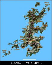
Working on updated maps of the Kaidan archipelago for my publications. This uses lots of beveled shapes, so Xara extensively used in this map. I've got two more large islands to create to complete this.
Link to larger file: Anshu Island
Member
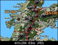
Here's a close in view around the imperial capital and environs - just to show the hand-drawn detail!
 Member
Fantastic as always.
-- Ben
-----------------------
Ben Morgan: ad1066 AT gmail thingy
Chapter 13 Press: www.chapter13press.com
Burn After Reading: www.burnafterreadingpress.com
Member
Thanks, ad1066
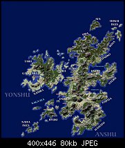
Next update, added Yonshu Island (left center). Next Gensu Island which is top left/top center, a colder climate similar to Hokkaido or southern Alaska. Almost done.
Michael
Member
Hi,
Looking good.
However for me the text at so many different angles spoils the map.
DD
Member
Many maps require non-horizontal labels, due to what's needed to be labeled and what space is available. Truth is, the map will receive far more extensive labeling before it's finished. Each river will be named, mountain ranges, some individual mountains, some forests. At this time a gazetteer with five or six text blocks of info are dedicated for each province. Right now it's about 20% labeled - so there will be lots more labels, and more reason to have different angles of labels. I appreciate that it is less appealing to you, however, not much can be done for the needs ahead...
Member
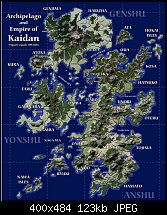
Finally done with the map - there are a few labels on wrong layers, which I need to fix before publication, but the main work is done.
This will get included whole in the Gamemaster's Guide to Kaidan, as well as divided by province and additional labels added to note rivers, mountains, ranges, forests and sites of interest. But those labels would be too small to show with all the islands.
Anyway, I'd say this map has taken me the longest to create - many hours hand-drawing, and just as many tracing the hand-lines with vector shapes, probably 20 hours in total.
@ DD - I made sure most of the labels are horizontal, only 2 areas in the sea had to be rotated to fit - Joto Strait and the Kaidan Sea. I hope that works better for you!
Enjoy!
 Posting Permissions

 Reply With Quote
Bookmarks