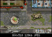
I was going to do a couple maps for a bridge across a canal, but that seems a waste, so here's just a single map to represent a "tile" of a bridge. This one has several abandoned vehicles, as well as a section of the bridge road has collapsed into the water below. This map was entirely created in 3D; modeled in Wings 3D, and textured and rendered in Vue Creator. But the road textures, sprawling weeds, as in the other maps were created using Xara Designer Pro, a vector drawing program. I also cut out the places in the bridge that fell out, as vector subtractions, square bevel, and rusty girders placed below the hole. Since the water was rendered in 3D, when I cut out the hole, I cut a hole all the way through the image, so had to create water behind to match the water in the river...enjoy!
GP
Here's an alleyway for the Abandoned Streets map set for sci-fi/cyberpunk/post apocalypse games. You get a bonus with this one, since the other maps feature streets which are much wider than alleys, you only get partial buildings in the corners - in this map, you get one full interior space (which I entirely created in 3D), a commercial shop or small manufacturer of some kind. The roof is gone, and the uneven floor is filled with dank water, and a small tree growing inside. There's a larger partial to the left side, with stairs going up, and a closed bay door north of it. So do you think I need a second alley map for the set, or is this enough?
GP
I'll do another alleyway map, later in the series, but I was in the mood to create the first of two maps for the subway system - this map is the entry level below the street level, but above the platform and track level, which will be the next map. Everything here was created in vector using Xara Photo & Graphic Designer 365 ($49), except for the escalator which you can only see the top of two escalators going down to the platform level. Those were created in 3D, modeled in Wings 3D and lit/textured/rendered in Vue Creator... okay, on to the subway platform... enjoy!
GP
So the next two maps for this set was chosen, because the subway entry and platform got very positive comments on other online communities - it's a needed set location for many games, I opted to create a 2 map small regional airport. Now these maps will come in multiple formats: 70 dpi JPG files for use in Roll20 (that's the resolution it limits), 100 dpi JPG files for use in other virtual tabletop applications, and as a layered PDF file for printing purposes. Since the filthy version of the airport is less optimal for some games, I placed the weeds and filth into it's own layer in XDP, so when I export this to PDF format, the user will be able to shut off the filth layer to see a shiney, new airport instead. I'm doing the same to the subway maps for the same purpose. The other street maps have way too many layers to make a practical attempt at creating layers you can turn on and off, so will leave that option off the rest of the set. The third map posted below is the same as the first map, with the weeds/filth layer shut off.. enjoy!
GP
Bookmarks