Welcome to TalkGraphics.com
Results 1 to 3 of 3
  1. #1
    Join Date
    Jun 2008
    Location
    West Coast, South Africa
    Posts
    84

    Default interactive street map... long lost 'skill'?

    ok here is the situation; i would like to use an image of an area with houses from Google Earth like the one attached. now i want to enable by click or mouseover for the user to have a popup appearing which provides the salient detail pertaining to the specific address - loooong ago i was able to produce something similar by 'slicing' the image - but i can't even recall the program or how it was done [25 years ago?]. now i sit with designer pro x10 and i am sure it can't be rocket science... a link or tip to kickstart my brain would suffice
    thanks in advance
    gabriel
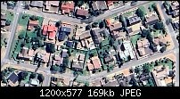
    Click image for larger version. 

Name:	googleearth_gAkOLCbhlE.jpg 
Views:	200 
Size:	168.9 KB 
ID:	133234
    '... and then there was Corel Draw v.2 for MS Windows 3 on my superfast 286'

  2. #2
    Join Date
    Apr 2012
    Location
    SW England
    Posts
    18,448

    Default Re: interactive street map... long lost 'skill'?

    Quote Originally Posted by ggsmit View Post
    ok here is the situation; i would like to use an image of an area with houses from Google Earth like the one attached. now i want to enable by click or mouseover for the user to have a popup appearing which provides the salient detail pertaining to the specific address - loooong ago i was able to produce something similar by 'slicing' the image - but i can't even recall the program or how it was done [25 years ago?]. now i sit with designer pro x10 and i am sure it can't be rocket science... a link or tip to kickstart my brain would suffice
    thanks in advance
    gabriel
    Click image for larger version. 

Name:	googleearth_gAkOLCbhlE.jpg 
Views:	200 
Size:	168.9 KB 
ID:	133234
    Gabriel, say you have 20 addresses.

    Create twenty Layers, one for each. Use a simple layer name, house name or number, enough for you to remember which to edit later.

    Add your specific detail for each address in its layer.
    Hide the layer.

    Over the image, create a shape.
    Make it 99% transparent.
    For each, set Link > Pop-up layer and set to the required Layer.

    You can embellish with a mouse-over effect or transition effect and also add pop-up text (Title).

    Do pay attention to data protection.

    Acorn
    Acorn - installed Xara software: Cloud+/Pro+ and most others back through time (to CC's Artworks). Contact for technical remediation/consultancy for your web designs.
    When we provide assistance, your responses are valuable as they benefit the community. TG Nuggets you might like. Report faults: Xara Cloud+/Pro+/Magix Legacy; Xara KB & Chat

  3. #3
    Join Date
    Jun 2008
    Location
    West Coast, South Africa
    Posts
    84

    Default Re: interactive street map... long lost 'skill'?

    thanks a lot @acorn , i endeavor to go that route; it is aimed at providing a neighborhood with better means of communication regarding safety, health and just plain common human interaction - a 'discipline' sadly falling by the wayside. conforming to the protection of privacy will enjoy high priority, thank you for mentioning it!
    regards
    g
    '... and then there was Corel Draw v.2 for MS Windows 3 on my superfast 286'


Tags for this Thread

Bookmarks

Posting Permissions

  • You may not post new threads
  • You may not post replies
  • You may not post attachments
  • You may not edit your posts
  •