

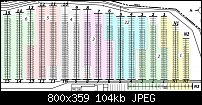
Egg, Yes they were not all the same size, my fault for trying to get the numbers in the whole row not actually counting the correct number of spaces in each row. I have corrected that now that I'm using Mikey's method of importing the PDF fields.
I have not used any of the Google tools like the Spreadsheet, so that would be another learning curve as well. We do need to print these end documents out, a couple a hundred a week.
So you are linking the Google spreadsheet to the .xar file in some way???
Pauland, the spaces should be the same size except for one or two rows that are for larger vehicles like big RV's or box trucks.
I tried to use Excel but I am not that familiar with drawing in Excel. Drawing the drive lanes and buildings I have to put in became a little difficult. That may be an option that we want to explore. It it just I am much more comfortable drawing in Xara and started there first.
I have loaded the PDF into a layer in Xara and it seems to be working rather well. But I have not gotten all of the drawing refitted into my 8.5" X 14" page size just yet.
Mikey, the current maps do not have the sections colored sections. I just think it is easier to identify the sections by putting the boundaries in different colors. Not even sure if we want to commit to printing that much in color right now?
Thank you all for the suggestions. I feel that I have a better way of doing it for now and will talk with the boss when I can, but will look at the other methods suggested as well. We want this to be as easy and update-able as possible each week.
Mark
P.S. here is what I have so far...

 Reply With Quote

Bookmarks