


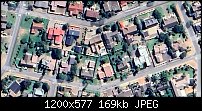
ok here is the situation; i would like to use an image of an area with houses from Google Earth like the one attached. now i want to enable by click or mouseover for the user to have a popup appearing which provides the salient detail pertaining to the specific address - loooong ago i was able to produce something similar by 'slicing' the image - but i can't even recall the program or how it was done [25 years ago?]. now i sit with designer pro x10 and i am sure it can't be rocket science... a link or tip to kickstart my brain would suffice
thanks in advance
gabriel


 Reply With Quote


 Acorn - installed Xara software: Cloud+/Pro+ and most others back through time (to CC's Artworks). Contact for technical remediation/consultancy for your web designs.
Bookmarks