OMG, you're a pro gamer!
I like you design work but am not really a gamer myself. Thanks for the link to the freebee though.


 Member
OMG, you're a pro gamer!
I like you design work but am not really a gamer myself. Thanks for the link to the freebee though.
Member
I get the gist that you're not a gamer - fully understand. The free product above is just to show you what I do, how the maps are used. I am more than a freelance illustrator, as mentioned I am an author, game designer and small publisher. Also understand that I don't play console video games, never have. I did create all the multi-player maps for Call of Duty: Advanced Warfare Strategy Guide, and was forced to play it a bit, while recording the maps at Activision, in Santa Monica, CA. Yes, I'm a gamer, but wouldn't call myself a pro gamer, though certainly pro publisher and illustrator. Note: I have 3 authors, all Canadians, that I also publish for, in addition to my own work. I'm not just a self publisher.
Last edited by Gamerprinter; 10 November 2020 at 09:26 PM.
Member
Thanks for the follow-up, Michael, appreciate it.
If you're not a pro gamer, you're a pro in the tabletop roleplaying games industry. :-)
Member
I definitely am that, an RPG industry pro.
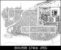
Now I don't have a new map to post, but trying to get the thread back to normal. Here's the full map of a hand-drawn piece I did for Paizo Publishing back in 2012, that I posted a very small portion of that map in post# 133. I couldn't previously post it due to NDA reasons, but that was 7 years ago, so we're way past the NDA.
While it is indeed fully hand-drawn, I did use Xara in the "sketch" rough draft I based the map. I created the borders of the river, the sea coastline, the smaller river, the canals, and the basic street layout as varying width lines, which I printed out large format to 4 quarters at 36 x 48 inches for each quarter. I then taped down the print, laid a sheet of 18# translucent bond paper taped to the top of that, and used the Xara generated lines as cues to partially trace and extrapolate from in doing the hand-drawn work. I hand-draw every building, drawing roughly 2 buildings per second for 10 minutes straight, then took a 5 minute break to rest my hand. For every 100 buildings I drew, I tried to include one temple or shrine, one cemetery and one market square. This got me into a Zen mode, quickly drawing buildings, thinking ahead on where to place temples, etc. as I drew - it was an interesting experience drawing that way. I did this for 4 hours a day over 4 days and created over 8500 buildngs.
Once I completed 1 quarter of the map, I sent it to Paizo Publishing, just to make sure we were on the same page with their design goals and my work thus far. When they saw the work, they doubled my commission. While I only did the hand-drawn line work version of this map, Paizo's inhouse cartographer did the full colorized version of the map so it would match the existing maps in the project - I could have done this work, but Paizo chose to do it this way. This was one of three maps included in the Dragon Empires Map Folio, a separate product than the adventure where it was originally included. The Dragon Empires Map Folio earned the 2013 Ennie Award for best Map Product (the Ennies are something like the Grammies for tabletop roleplaying game industry).
Anyway, roughed in Xara, finished by hand, the City of Kasai, population 120,000 (approx), as part of The Empty Throne module of the Jade Regent Adventure Path, by Paizo Publishing (a major RPG publisher).
Enjoy!
Member
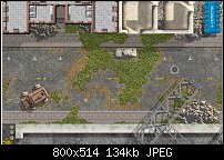
I decided to finally create a post-apocalypse specific map, calling this abandoned street - pretty simple, though extremely detailed to fit a placed unlived in for decades. I place for a street fight, probably. An idea I had in mind for a while. The weeds in the cracks in the streets took forever to do, though... enjoy!
GP
Member
And they look very good. But the buildings, sidewalks and other structures look all a bit too orderly, too pristine after decades without any maintenance, and need to show a bit more decay, crumbling, rust.Originally Posted by Gamerprinter

Member
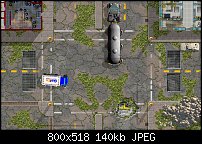
Legitimate critique, though I'm done with that map. So here's the next map in the series of 9 - 12 street maps, but the buildings in this next map is more grungy to meet your critique. I may not post all the maps for this coming set until it's released as a map product, but this is map two, of the Abandoned Streets map set. This is an intersection of the same two lane street at the previous crossing a 4 lane street in town. There's a water damaged pit exposing some water pipes below. There is drainage grates, with one of them partially opened to the drain system below. Enjoy!
GP
 Posting Permissions

 Reply With Quote
Bookmarks